
Gin Peak is a moderate length single day ski tour located in Callaghan Country. It is accessible from Whistler Olympic Park, which is just a short drive from Whistler proper.
Its location, terrain offering, and medium difficulty make it a popular destination for intermediate backcountry skiers, snowshoers, and splitboarders. On a weekend day in the winter you can expect to find many people making the climb up to Gin Peak.
Gin Peak Ski Tour Overview
Starting from the biathlon area parking lot of Whistler Olympic Park, the Gin Peak ski tour is a 10-11km round-trip adventure. The tour starts at an altitude around 845m and gains about 900m of elevation, reaching the peak at 1,750m. On average, the roundtrip tour takes 5-6.5 hours depending on the ability, fitness level, and urgency of your group.
We did Gin Peak in late December. However, I would say this adventure is best undertaken between the months of January and April, as the first part of the ascent winds back and forth across a small creek. While crossing the creek is as simple as stepping over it, sufficient snow would help fill it in, making the ascent a little less technical.

Access Gin Peak from the Whistler Olympic Park
As mentioned, the most popular place to start the Gin Peak ski tour is from the biathlon parking lot in the Whistler Olympic Park. The Whistler Olympic Park gates don’t open until 8:30am on weekends and 9:00am on weekdays. There is the option to tour 3km from the gate to the parking lot if you want to get an earlier start.
Driving Distance to Whistler Olympic Park
From Whistler – 23km | 25 minutes
From Squamish – 57km | 50 minutes
From Vancouver – 119lm | 1 hour 45 minutes
The daily admission fee for backcountry skiing is $15 per vehicle, payable at the front gate. The gate attendant will give you a piece of paper to fill out and put on your dashboard. This is so the park rangers can see if anyone is still out in the backcountry when the park closes at 4:30pm. You must be out of the park by the 4:30pm close, so keep this in mind while out on your tour.
The attendant will also give you your access pass, with the park ranger’s phone number on it. Therefore, if you are going to be late you can notify the park staff. Thankfully, as a result of the infrastructure put in place for the 2010 Olympics, there is cell service along the entire Gin Peak ski touring route.

The Climb to Hanging Lake
From the biathlon parking lot, take the cross country trail that goes to the right of the biathlon shooting range. About 50m beyond the shooting range, take the path on your left that climbs into the forest. This is a summer hiking trail that snakes its way up through the woods to Hanging Lake.
The trail up to Hanging Lake is very conspicuous, so don’t worry too much about navigation. However, it is technically challenging as a result of small steep areas and narrow pathways. In early season, you’ll also be required to cross a very narrow creek about 10 times as the pathway snakes back and forth across it. Some of the crossings are a bit tricky, so if you’re still getting used to having touring skis on your feet, you may want to wait until later in the season when the creek fills in with snow.
While the ascent to Hanging Lake isn’t overly long, we found some parts of the trail to be quite tricky as there are some very steep sections that require technical maneuvers and a lot of focus. I would definitely recommend using your stickier skins and watching some videos on steep climbs for this tour.
Once out of the woods you’ll come to a boulder field, at which point you’re very close to Hanging Lake. Climb up to the left to reach Hanging Lake, at which point you’re about 60% of the way through the ascent, in terms of both distance and elevation.

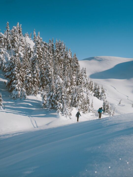
Hanging Lake to Gin Peak
When you approach Hanging Lake you’ll see that there is a vast amount of skiable terrain surrounding the lake. After being up here I think that Hanging Lake would be a great place to set up a tent and spend a few days skiing a bunch of nearby lines. I haven’t looked into the feasibility of this yet, but colour me intrigued.
Straight across the Lake is Rainbow Mountain. On the right side (East) of the lake is Gin Peak. You’ll likely find a few different skin tracks up to the ridge, choose one that suits you best or break trail to form your own. Once you gain the ridge, it’s a relatively mellow tour up to the top of Gin Peak. On a clear day, you’ll have epic views of Rainbow Mountain, Hanging Lake, Whistler-Blackcomb, and Black Tusk off in the distance.


Avalanche Considerations
As with all backcountry skiing, always check the local Avalanche Canada forecast for the Sea to Sky Region before embarking on a ski tour. On top of this, ensure that you have your avalanche safety gear, and are trained how to use it. Avalanches are not uncommon in the Callaghan area, and fatal avalanches have occured here as recently as 2020/21.
The eastern face of Gin Peak is shaded from the sun more than the other slopes surrounding Hanging Lake. This makes it (typically) a safer face to ski, but always be on the lookout for signs of instability or avalanche activity.
Below you will find a topographic map of Gin Peak with a slope angle overlay. This is useful for choosing your line based on the current avalanche conditions.

The southern and northern ridgelines off of Gin Peak provide the safest descents.
The Descent from Gin Peak
We opted to ski off the peak down the mellow ridgeline that we came up. From here, we carried our speed to where we could ski down to the lake. The skiing down to the lake was magical, even though we were clearly not the first ones to ski that area. We were still able to find some powder stashes and enjoy the descent down to the lake. We carried our speed as best we could to the exit from Hanging Lake, but still had to take off our skis and bootpack two minutes up to the boulder field entrance.
We traversed across the top of the boulder field and skied down along the skier’s left (South) side of the creek. There is always the option to ski down the same trail that you come up through the woods. But we choose the gladed area on the South side of the creek, because the trail didn’t seem that fun.
The glades were fantastic for the first part of the descent through the forest. In hindsight, we should have kept further to skier’s left after the first few hundred metres of gladed skiing. At one point we ended up in the gully next to the creek, which was tricky to navigate out of in the deep snow. If you keep to skier’s left, you should be able to avoid such troubles.

Trip Summary and Gaia Link
We were fortunate enough to do Gin Peak on a spectacular bluebird day, with great snow. Although the climb up through the woods was a slog as a result of early season snow (and creek) conditions, it was great Type 2 fun. We took our time, enjoyed the day, and stopped for a summit lunch and some photos at the top.

A summary of our trip. Here is the Gaia Link.
Looking to upgrade your gear for touring this season? Check our our ultimate guide to backcountry ski gear.
Jeff
Monday 4th of January 2021
Wow, looks like a great your! Thanks for the detailed write up.