

Beehive Lakes is a beautiful out-and-back hike located between Bonners Ferry and Priest Lake. Showcasing spectacular views of the Selkirk Mountain range and two pristine turquoise alpine lakes, Beehive Lakes is, unsurprisingly, an increasingly popular day hike and backcountry camping destination among Northern Idaho visitors and locals.
Beehive Lakes Hike Stats
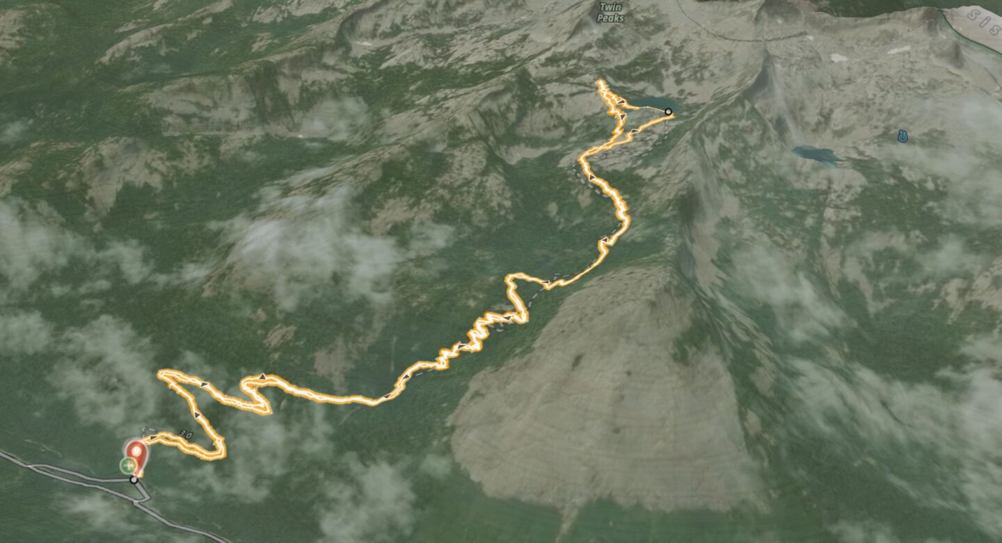
Starting elevation: Beehive Lakes Trailhead at 4,440ft (1,350m)
Ending elevation: Beehive Lakes at 6,560ft (2,000m)
Elevation gain: 2,050ft (630m)
One-way distance: 3.8 miles (6.2km)
Roundtrip distance: 7.6 miles (12.4km)
Estimated time: 4-5 hours
Getting to Beehive Lakes
The Beehive Lakes Trailhead is located 19 miles down the Pack River Road from Highway 95. From the highway, the road quality starts out fine but deteriorates fairly quickly. It is passable in most vehicles, but 4X4 and high-clearance vehicles definitely fare better.
There are many hiking trails along the road that access other areas such as Bottleneck Peak, Mount Roothaan, Roman Nose, and Silver Dollar Peak. The trailhead parking lots for most of the common hikes are marked well with signage along the way.
Parking at the trailhead is very tight. The actual parking spots are limited to maybe 10 vehicles, so a lineup of cars down the road typically forms. We showed up fairly early in the morning and still missed out on the designated parking, but we were able to grab one of the first spots along the shoulder of the dirt road. Still very close to the trailhead.
Driving Times to Beehive Lakes Trailhead
From Sandpoint: 1h 5min (31 miles)
From Bonners Ferry: 1h 15min (40 miles)
From Coeur D’Alene: 1h 55min (76 miles)
Hiking to Beehive Lakes
The trailhead is conspicuous, starting just on the other side of the bridge at the edge of the parking lot. From there, the trail climbs steadily over a series of switchbacks. The trail is well-established which makes navigation very straightforward. The first 3.3 miles (5.4km) switchbacks very steadily through the woods at a consistent incline. With a daypack you can work your way up at a good cruising pace. But we definitely saw some backcountry campers who were working hard to lug their big packs up there.
Once out of the woods at around 6,200ft (1,900m), you come to an open expanse of granite with more sparse trees. At this point the first views of the Selkirk Crest start to come into view and you can identify some of the peaks.
You can pick your own path through the open granite field; as long as you’re going upwards the ridge will funnel you towards the main alpine lake. The slope flattens out as you approach the lake and you’ll start to get close up views of Twin Peaks.
Arriving at Beehive Lakes
Once you arrive at the lake, you’ve got options! Brave souls will dive in for an alpine swim. You can walk around the lake and find a nice vantage point to stop for lunch. Or if you’re feeling energetic you can continue your way up to Twin Peaks. With some scrambling you can get a spectacular view of the lake and the valley below.
If you’re camping, there are plenty of short day hikes to do from the lake. You can go up to Twin Peaks, visit the other Beehive Lake, or traverse along the ridge for endless views of the Selkirks.


zortilonrel
Thursday 20th of May 2021
Hi my friend! I wish to say that this article is amazing, nice written and include almost all vital infos. I would like to see more posts like this.